Tuolumne Meadows Vacation
Day 9
Unicorn day hike
Having spent a realtively relaxing day in Mammoth, we decided that we were
recharged enough to try another climb. So, we headed out from camp
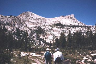
toward Elizbeth lake, which is at the foot of the mountain known simply
as "The Unicorn". The picture on the right shows the TrailManor in
the background.
The hike from the campground was a bit of a way, with moderate elevation
gain. As we hiked, we met a river that flows out from Elizabeth lake.

The lake was beautiful, especially with The Unicorn hoevering at its shore.
Unfortunately, the fact that its so close to the campground means that
its a relatively easy target, so there were 3 or 4 families there other
than us.

As you can see it the picture, The Unicorn is a two-peaked mountain.
Peaks in Yosemite that were under the glaciers were shaped into rounded
shapes, while those which stuck out above the gracier had their sides torn
away, causing sharp peaks. This leads me to believe that the "rump"
of The Unicorn (on the left) was under the glacier and hence rounded, while
the "horn" (on the right) stuck out above the glacier. I'm not sure
if this is true; you should CYLPR (consult your local park ranger).
After a quick lunch, Dad and I headed out towards the mountain while Mom
and Trish stayed at the lake.
When Dad and I climbed Ragged Peak, we had with us FRS (Family Radio Service)
radios. These walkie-talkie-like deivces have a range of about 2
miles. So, we were able to talk to the folks down below and let them
know where we were. Unfortunately, a six fpot high target is pretty
hard to see when its a couple miles away. I solved that problem by
taking a signal mirror on the ascent of Unicorn, so that I could flash
them with the mirror to let them know where I was.
About half way up, I turned and saw that Lembert Dome was in the sun, while
surrounding forest was in the shade from the clouds above. While
Lembert looks quite intimidating from the campground, it didn't look like
much here.

As we got up higher, we could see the lake from Unicorn:

As we continued up, we were high enough that we ran into tiny snow fields
in places where the rocks provided just enough shade for the snow to stay
frozen from day to day. That's Unicorn's "horn" above.

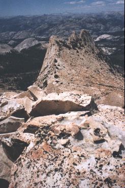
After quite a climb, we made it to the saddle. Here's a really cool
panorama I took of the view. From left to right, we have the rump
of Unicorn, the Cock's Comb, Echo Peak, Cathedral, the horn of Unicorn,
and Lembert dome.
Hold mouse key and move mouse to pan. Use 'a' and
'z' to zoom in and out.
Since we were so close, I decided I would attempt to summit the rump, while
Dad would wait in the saddle. The 3-way communications got pretty interesting
as I ascended. While it looks quite smooth from a distance,
in reality the rump is made up of at least 3 layers deep of ottoman to
golf cart-sized rocks. The higher I got, the larger the rocks got,
and the more perilous it became. The ridge narrowed to about 20 feet
wide. I wasn't in any danger, but looking over the snowfield at tiny
Elizabeth Lake below ws enough to make me start shaking.
On the snowfield, the snow was a light pink hue. Called "watermellon
snow", it is caused by some sort of microorganism that lives in the snow.
Don't eat it!
Finally, I got to the top. Strangely, there were a dozen or so butterflies
fluttering right around the peak. I have no idea what they were doing
there; there were no flowers from which to feed, etc. Maybe they
were just tourists. Here's a picture from the rump towards the horn:
In addition to the butterflies, there was quite a bit of marmot scat in
amongst the rocks. I had visions of running into a Bubonic Plague-infested
Marmot, becoming delierious, and falling off the mountain (Hey, it could
happen!)
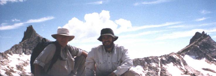
Finally, I carefully picked my way don to the saddle, where Dad was (semi)
patiently waiting. Here's a group shot, with Cock's Comb and Echo
Peak in the background.
When we started down the mountain, we had to be a little carefull - Unicorn
has several cliff structures running along its face. In order to
be sure we came down the same way we came up, we used our GPS to retrace
our steps. Here's a picture of Dad comming down the mountain, with the
"Rump" in the background:

In this picture, you can see how the mountai descends for a while and then
drops of steeply. If we hadn't stayed to the left, we would have
gone over the edge:

At last we got to the bottom. Before heading back to camp with Mom
and Trish, I got a last picture of the mountain:


