Archive → February, 2005
More snowshoeing
Jason and I went snowshoeing today. The cloud ceiling was at about 1000 feet, and the weather was bad enough that the GPS didn’t work.
I think we hiked 4 to 5 miles. From the Tuxedo train station, we hiked up the Ramapo-Dunderburg trail to Black Ash pond. The west end of the pond is built up by a natural rock wall, and from the other side it creates a small waterfall:

From there, we took the Blue Disc trail to the Tuxedo-Mt. Ivy trail. Near that junction is “Claudius Smith Den”, one of the mountain hideouts of Claudius Smith, a revolutionary-war-era criminal. Jason is in the lower left corner of the picture:

From there, we took the Tuxedo-Mt. Ivy trail back to the Ramapo Dunderberg trail, then hiked north along a gas pipeline easment to the Triangle trail, which met back up with the Ramapo Dunderberg trail.
Wedding at 770
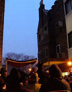
Tonight, Trish and I went to the wedding of Moti Wilhelm, the eldest son of Rabbi and Rebbetzin Wilhelm, the Chabad Shluchim in Portland, Oregon. We were a little slow leaving the house, so we got to Crown Heights right before the wedding started. Unfortunately, we were a little under-dressed, as this wedding was held outdoors.
Did I mention it’s February? It was in the low 30s. Thankfully, we all seemed to have enough cold weather gear to stay warm.
Here’s the Chuppah from a couple angles:
 |
 |
Moti and his wife-to-be. Chabad women use a really thick veil:

The chuppah ended around 6:30. Since the kids usually go to bed at 7:30, we decided to head home. Although Trish didn’t get to say hello to the Rebbetzin, I did see the Rabbi, and Trish saw two of her former coworkers from the Chabad school.
Hike to Mostly Perpendicular
Went on a hike this afternoon. It was a 4.6 miles, and I was out from 3:15 to 5:30ish. Here’s the route and profile. I started at the bottom and proceeded clockwise:


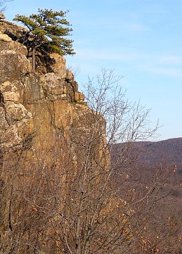
The hike started at the end of Johnsontown Road in Sloatsburg. At about 8/10s of a mile, the climb up onto Almost Perpendicular, a cliff, began. I took a brief detour to try and find Dater’s Mine, but I wanted to be sure I got back before dark so I stopped looking after a couple minutes. Before the climb, I climbed up onto a little ridge to take in the view:

From there, I could see the face of Almost Perpendicular:
I went back down to the trail which climbed up the back of Almost Perpendicular. From there, I could see the Harriman Visitor Center, almost a mile away:

After a brief respite, the trail climbed up through a draw in a small cliff face. When I popped up onto the top of the cliff, there was a deer standing about 30 feet away. We were both quite surprised:


I continued on as the sun began to set:

As I approached these ice walls, I was walking on a leaf covered flat area. Suddenly, I stepped through into water. A layer of ice had formed over a creek, and leaves had covered the ice. Quite the surprise…..

A bit farther on, I passed “Elbow Brush”, a narrow crevasse through a pile of rock:

After about 2 miles, the “Blue Disk” trail met the “Tuxedo/Mt. Ivy Trail”. I followed that for about a mile, then took the “White Bar” trail for 1.6 miles back to the car.
All in all, it was a nice little hike!